Starting in the 1800s and at least by 1906, the operator of the lime quarry near Marble Valley was Henry Cowell Lime Company. As reported by the California State Mining Bureau, the lime was hauled two miles from the kilns and shipped by rail at Cothrin Station, located several miles southwest of Shingle Springs, CA on Southern Pacific’s Placerville Branchline. In my estimation using Google Earth, the quarry was closer to three miles from Cothrin Station.
In 1918, The El Dorado Lime and Minerals Company opened the El Dorado limestone mine in Marble Valley. Limestone was previously quarried and burned in stone kilns, at least one of which is still present today. The quarry was also known as Sprekels Quarry. The last time I was in the area in about 2003, many foundations and basements were scattered throughout the area as well as an old wagon near the kiln. I noted that there was old mine cart rail used in the foundations and basement walls of the old structures.
The original narrow gauge railroad built to haul the limestone from the mine area was constructed from an area south of the quarry to an area adjacent to MP 133.4 on Southern Pacific’s Placerville Branch known as Limestone, and was approximately one mile in length. Two Lima built two truck shay steam locomotives handled the traffic between the quarry, at least 1 kiln (which is still present today), and the warehouse next to the Southern Pacific. The company took possession of a narrow gauge Plymouth switcher which was later standard gauged.

My copy of the Southern Pacific Valuation Maps shows at least two tracks in this area, a spur to a kiln, three dwellings, a shack, an oil vat and another structure. Currently I am not sure what type of trans-load facility may have existed between the two railroads but tracks from both railroads paralleled each other for a short distance.
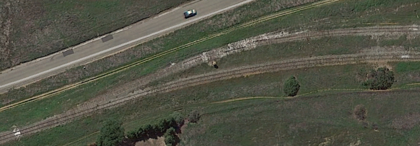
 Currently, a trucking road follows what I believe to be a significant or majority of the right of way from the trans-load location back to the mine. Having personally walked the right of way, I observed the grade was less than gentle, necessitating the use of shay locomotives.
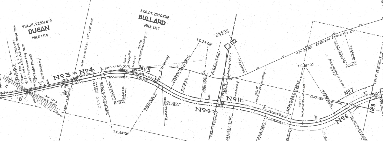
In 1931, The El Dorado Limestone Company was formed and took over operations of the mine. Around or after this time, it is assumed that the narrow gauge railroad was abandoned in favor of a standard gauge railroad 1.9 miles in length, with a direct connection to the Southern Pacific Railroad at Bullard. This facilitated a direct connection for handling of rail cars the could be loaded close to the mine, eliminating the need for trans-load as was probably the case with the narrow gauge. The company also had two more Plymouth switchers it used on the standard gauge portion of the railroad.

Photo from quarriesandbeyond.org.
The mine operated until its closure in the 1970s and the mine shaft was then allowed to flood with water. Through the 1980s, crushing equipment on the surface was then used to process limestone quarried from the Gallo Glass mining operations in Marble Valley which was brought in by truck. During this time, Southern Pacific ran their engines up the spur to spot empties and retrieve loads. Maps today today show the name of the area around the mine as Sprekelsville. The track near the mine also served as a trans-load point for plastic pellets destined for PW Pipe’s factory in Cameron Park, with the trucks traveling up the road occupying the former narrow gauge right of way. During severe storms in Southern California, the SP ran work trains to the mine spur and loaded cars with large boulders and rip rap for use in shoring up severe mudslides in the Mojave area during the 1980s.
Today, all that is left at Bullard is a siding, telephone booth and remnants of the lime spur’s switch which was removed recently by the El Dorado Western Railroad. The El Dorado Western has also removed one of the switches on the West end of the siding for use on their railroad from Shingle Springs to El Dorado. A significant portion of the lime mine spur is now Amber Fields Drive, which is mostly within a gated community.

At the loading site near the mine, a railroad scale remains, its rails isolated from any other track.
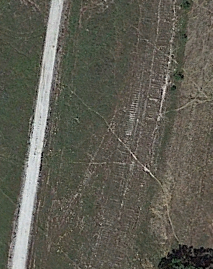
From satellite imagery, one can still discern the outline of railroad ties leaving the Amber Fields gated community and paralleling a gravel road to the mine.

Photo by David Dawson from 1991 of the largest remaining kiln.
References:
http://www.thevillageofmarblevalley.com/project-history.html
http://quarriesandbeyond.org/states/ca/quarry_photo/ca-el_dorado_cothrin_station-garden_valley.html
http://quarriesandbeyond.org/states/ca/quarry_photo/ca-el_dorado_latrobe-shingle_springs_2.html
http://www.pacificng.com/template.php?page=roads/ca/edlmco/index.htm
http://www.trainweb.org/foothill/edlmmain.html
http://wikimapia.org/10821711/El-Dorado-Limestone-Mine
Leave a Reply
You must be logged in to post a comment.